
Mount Manaslu (8,163 m / 26,781 ft) is the eighth highest mountain in the world and a long-time favorite among serious mountaineers. It sits in the Gorkha district of Nepal, inside the Manaslu Conservation Area, which is also the setting for the Manaslu Circuit Trek.
Everest can be climbed from both its north and south sides, but Manaslu is different. Its sides have their own climbing histories, approaches and character. This guide explains the Manaslu South Face vs North Face question, how each side was climbed, and what it all means for your trek.
Quick Answer: Manaslu South Face vs North Face
- The north side is known for the Northeast Face, the historic standard route. The Himalayan Database records it as the normal route, and it was used for the first ascent in 1956.
- The south side is steeper and more technical. Its best-known line is the 1972 route by the Tyrolean expedition, often called the Messner route.
- Both sides have rock, snow, ice, ridges and glaciers, but they are fed by different glaciers and reached through different valleys.
Understanding Manaslu’s Face Terminology
Manaslu is a large, complex massif. Climbing literature usually refers to five orientations: the North, Northeast, South, South-Southwest and East faces. They are not different names for the same wall. Each describes a distinct side of the mountain.
North Face vs Northeast Face
The North Face looks directly north. The Northeast Face sits between north and east. The two should not be treated as the same thing. The Himalayan Database lists the standard route specifically as the Northeast Face (NE), and its records show this face was used for the 1956 first ascent and many expeditions since. So when people say “north side” in a climbing context, they most often mean the Northeast Face.
South Face vs South-Southwest Face
A south face points directly south. A south-southwest face points halfway between south and southwest. The 1972 Messner route is often called the South Face route, while newer climbing literature may call it the South-Southwest Face. The two terms can refer to the same route, so check which route and source is being discussed before assuming they are separate walls.
In short: the northern climbing side is usually called the Northeast Face. The southern side is generally called the South Face, though some routes are described as South-Southwest.
Where Are Manaslu’s South and North Faces?
The faces lie on opposite sides of the massif in the Manaslu region of Gorkha. Each is linked to different valleys, glaciers and approaches.
Location of the South Face
The South Face rises from Manaslu’s southern massif and looks toward the upper Nubri Valley. Key features include:
- Pungyen (Pungen) Glacier, an important feature on the southern and southeastern side. Past expeditions approached from the south and set up base camp on its moraine.
- Thulagi Glacier, which also feeds this side.
- Terrain of steep snow and ice slopes, exposed rock, ridges and glaciated ground.
- Viewpoints around Samagaun and Pungen, which give views toward the southern side.
Location of the North Face
The northern side is a rugged, high-altitude landscape of glaciers and snow peaks. Key features include:
- Manaslu Glacier, important on the northeastern side, running from the mountain toward Birendra Lake and the upper Nubri Valley.
- Budhi Gandaki River, which flows mainly from the eastern and northern slopes of the massif.
- Northern and northeastern slopes that rise above the areas around Birendra Lake and Samagaun.
How the Mountain Changes as You Walk Around It
Manaslu has no fixed “front” or “back.” What you see depends on where you stand.
On the Manaslu Circuit Trek, trekkers meet the northern and northeastern aspect from Samagaun and Manaslu Base Camp. The viewing angle then shifts gradually toward the eastern and southern sides. The high alpine areas of Bimthang and the trail toward Hampuk also give good mountain views along the circuit.
North, northeast and northwest are related but geographically distinct directions. Keeping them separate makes it easier to read route descriptions, follow climbing history and understand what you are seeing on the trail.
Comparison Table: South Face vs North Face
| Factor | South Face | North Face |
| Position | Southern side of the main summit | Northern side of the main summit |
| Terrain | Rock, snow, ice, ridges, glacial features | Rock, snow, ice, ridges, glacial features |
| Climbing history | South-side routes include the 1972 south-southwest ascent | Documented routes on the northeast and northwest aspects |
| Trekking relevance | Southern approaches and selected viewpoints | Northern approaches and selected upper-circuit viewpoints |
| Photography | Southern profile and surrounding valleys | Northern profile and high-altitude landscape |
Shape and Structure of the South Face
The South Face is made up of rock, snow, ice and glacier features. It is closely tied to the Pungyen Glacier and the valleys on the southern side. Reading it from the bottom up, the terrain follows a clear sequence: valley → glacier → steep slopes → ridges → summit.
Glaciers and Ice on the Southern Side
The Pungyen Glacier is the main glacier on the south. It carries rock debris downhill and carves out glacial valleys. Its surface also changes through the year as fresh snow, melting ice, exposed rock and debris alter how it looks.
How the South Face Looks From Different Viewpoints
The appearance of the South Face depends on where you stand, how far away you are, the angle and the weather.
- A view from the southern valleys may show glaciers, snowfields, rocky slopes and ridges together.
- A view from the southwest shows a different set of ridges.
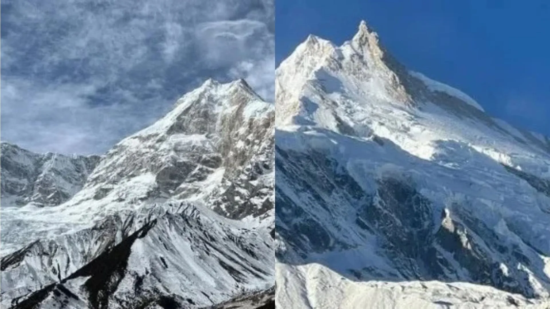
- Photos taken from different valleys or heights can look very different even though they show the same general southern side.
This is why “south,” “southeast” and “south-southwest” describe different viewing aspects rather than separate mountains.
Shape and Structure of the North Face
The north face is defined by glaciers, snow-covered slopes, rocky ridges and high-altitude valleys. Through ridges and snowfields, it blends gradually into the northeastern and northwestern aspects.
Northern Profile and Surrounding Ridges
The northern profile is the outline of Manaslu as seen from the north, including the summit, snowfields and ridges. The mountain rises above a rugged landscape of glaciers, snow slopes and linked ridges. Several ridges run down from the summit and separate one slope or glacier area from the next. From Samagaun and the wider Nubri region, the mountain reads in layers: valley floor, steep slopes, ridges, then summit.
Glaciers, Snowfields and High-Altitude Terrain
This side combines glaciers, snowfields, steep slopes, rocky ridges and high valleys. Seasonal snow, melting ice and wind keep reshaping the surface. The Manaslu Glacier is a key feature of the northern and northeastern area, and its surface stays snow-covered for long periods, particularly at higher elevations. The overall character is cold and steep, with rocky slopes, ice, snowy ridges and exposed terrain.
Why Manaslu Looks Different From the North
- Viewpoint and distance
- Terrain and glaciers
- Sun angle and lighting
- Cloud cover, snow conditions and season
Two photographs of the same northern aspect can look unlike each other because of camera position, light and weather.
The Manaslu Avalanche Zone
The Northeast Face is one of the most avalanche-prone sections of the mountain. It holds dense, active serac formations, which makes it a serious hazard for climbers.
The north side is steep and narrow, so it acts as a natural funnel for snow and ice. As material moves through these narrow sections it gains speed and becomes more concentrated, which raises the avalanche risk considerably.
Sunlight, Snow and Weather: South vs North
Sunlight, snow cover and weather can differ between the two sides, but not in a fixed way. Local conditions depend on slope direction, elevation, season, wind, cloud cover and surrounding terrain. Sunlight controls snowmelt and surface temperature. At high elevations, clouds, snowfall and strong winds can arrive quickly on either side. Both faces belong to the same mountain and share the same broad climate.
Need Help? / Call Us
+977-9845548583 or Chat with us on WhatsApp
Ask a Question?
Does Snow Build Up Differently on Each Face?
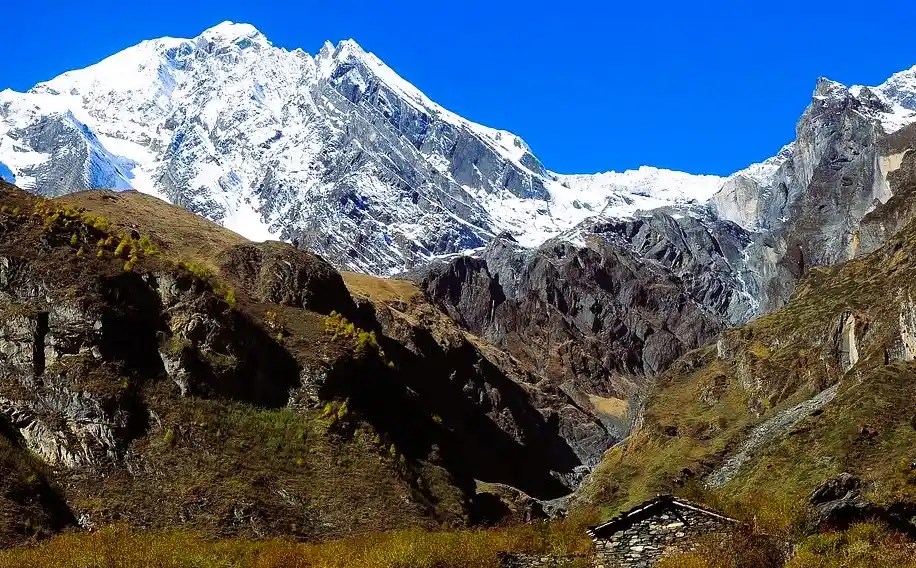
Snow cover depends on sunlight, wind, precipitation, elevation and slope angle. Sun-exposed slopes tend to melt faster, while shaded slopes hold snow longer, and this varies by season and by individual slope.
In the Northern Hemisphere, north-facing slopes generally get less direct sunlight, so snow and ice last longer. South-facing slopes receive more solar radiation, which can increase melting and expose more rock.
How the Seasons Change Both Faces
| Season | What You Will See |
| Spring | Lower slopes show more bare rock and terrain, while snow stays on higher ground. Snow conditions vary with wind redistribution and slope exposure. |
| Summer (monsoon) | Lower and middle slopes can look greener. Monsoon clouds and rain often hide the upper mountain, which stays covered in snow and ice. |
| Autumn | Clear weather and sharper views, with snow and ice mainly at higher elevations. Autumn photos can look quite different from summer ones. |
| Winter | Cold temperatures and snowfall increase snow and ice cover. Strong winds spread snow unevenly, and ice persists at high elevations. |
Practical tip: snow cover alone is not a reliable way to tell which face you are looking at, especially in winter. Use landmarks, valleys and your position on the trail instead.
First Ascents and Climbing Routes
Manaslu’s north and south sides have been climbed by different routes.
Which Side Was Climbed First?
The first successful ascent came from the northeast side. On 9 May 1956, Gyaltsen Norbu Sherpa and Toshio Imanishi of Japan reached the summit, as part of a Japanese expedition led by Yuko Maki. The team approached via the Manaslu Glacier and the northeastern route, setting up camps higher on the mountain toward the top. The Himalayan Database records this route as the “NE Face,” so Northeast Face is the most accurate term when discussing the first ascent. It later became the mountain’s standard climbing route.
When Was the South Face First Climbed?
In 1972, an expedition led by Wolfgang Nairz opened a route on the south side. Reinhold Messner reached the summit alone after his teammate Franz Jager turned back. The southern climbing history is more technical and became an important chapter in mountaineering.
- The American Alpine Club describes this as Manaslu’s third ascent and the first ascent of a new south-southwest face route.
- The Himalayan Database lists the route as the “S Face,” while other climbing sources call it the south-southwest face.
Both names point to the same route, so check which source you are reading.
Northeast Face vs South-Southwest Face: How the Challenges Differ
Difficulty on Manaslu depends on the route chosen, not on whether climbers approach from the north or south. Both sides share strong winds, heavy snowfall, avalanches, poor visibility and fast-changing weather.
| Route | Main Hazards |
| Northeast Face | High-altitude snow, glaciers and crevasses. Snow conditions and weather can block the route and raise avalanche risk. |
| South-Southwest Face | Runs near the Thulagi Glacier. Hazards include seracs, crevasses, steep snow and ice, and technically demanding terrain. |
On either route, camps, fixed ropes, glacier crossings, equipment and acclimatization also affect how hard the climb becomes.
How to See Both Sides on the Manaslu Circuit Trek
The Manaslu Circuit Trek is a scenic route through the Manaslu region of Nepal. It starts through lower villages such as Soti Khola, Machha Khola, Jagat and Deng, passing forested valleys, high mountain settlements and traditional villages. As the trail follows the Budhi Gandaki Valley through Samagaon and Samdo and on toward Larkya La, your view of the Manaslu massif keeps changing.
Trail Viewpoints in Order
- Lho and Shyala: Manaslu first appears clearly here. At Lho it rises above the valley. Shyala gives a wider panorama that also includes Himal Chuli and Ngadi Chuli.
- Samagaon: A broad alpine valley village close to the mountain, commonly used as an acclimatization stop. Side trips go to Pungyen Gompa, Birendra Lake and Manaslu Base Camp.
- Samdo to Larkya La: The views widen into a broad Himalayan panorama. Near and across Larkya La, peaks such as Himlung Himal, Cheo Himal and Kang Guru become more prominent.
Local tip: Manaslu is the main summit of the massif, so not every big snow peak you see is Manaslu. The circuit offers many angles on the mountain, not a simple north-versus-south choice.
Where Can You See Manaslu’s Southern Side?
Once the trek reaches the upper Nubri Valley, you get some of the clearest views of the southern side. Lho, Shyala and Pungyen Monastery bring you progressively closer.
- Lho: One of the first major viewpoints. Manaslu rises clearly above the village on the main trail, though nearby ridges may hide its lower sections. It lies in the upper Budhi Gandaki Valley and looks toward the southern and southeastern aspects.
- Shyala: The next village, with a broader view of Manaslu alongside Himalchuli and Ngadi Chuli.
- Pungyen Monastery: A side trip leads toward the Pungyen Glacier Valley, where Manaslu rises above the glacial landscape.
These viewpoints show different angles of the southern, southeastern and eastern parts of the massif. It is more accurate to treat them as separate aspects than to call all of them “the south side.”
Can You See the North Face From the Upper Circuit?
The upper circuit, from Samagaon toward Samdo, Dharamsala and Larkya La, gives changing views of the massif. It is better described that way than as a guaranteed view of the true north face.
- Samagaon: Manaslu looks very close. Some sources call the visible side the north face, others a glacier-covered side.
- Samdo: Different views of Manaslu and surrounding peaks.
- Beyond Samdo: Toward Dharamsala and Larkya La, the focus shifts to the wider Himalayan landscape and other peaks.
Best Photography Viewpoints on the Manaslu Trek
Each of these spots shows the massif from a different angle.
Lho
One of the first major photo stops. The mountain rises above the village, and Ribung Gompa, prayer flags and traditional houses add cultural detail to the frame.
Shyala
Open terrain gives clear, wide views of Manaslu and nearby peaks. It suits shots of the whole massif better than any single face.
Pungyen Monastery
A closer, panoramic view of Manaslu and surrounding mountains. The monastery, prayer flags and local houses make a good foreground for landscape photos. It sits in the Pungyen Valley above Samagaon, in open high-altitude terrain facing Manaslu.
Samagaon and Birendra Lake
Samagaon is the largest and most important village in the upper Nubri valley. It is more than a rest stop: it is a key base for high-altitude acclimatization. Birendra Lake reflects the surrounding peaks on calm days, and the lake, rocky ground and snow peaks make strong landscape shots.
Manaslu Base Camp
One of the closest views of the mountain, framed by glaciers, rocky slopes and ice-covered peaks. It feels far larger and more imposing than the views from lower villages like Lho or Shyala. The camp sits on the northeastern side near the Manaslu Glacier and is the main expedition base for climbers on the standard northeast route.
Need Help? / Call Us
+977-9845548583 or Chat with us on WhatsApp
Ask a Question?
Do You Need to Complete the Full Circuit to See Manaslu?
No. Several villages and viewpoints along the route give some of the best views of the Manaslu massif, and you can turn back without crossing Larkya La or finishing the full circuit.
For a closer look at the mountain and its glacier landscape, you can add a side trip to Pungyen Monastery. This takes extra time and proper preparation.
A shorter trek can still deliver strong views, but it is not the same experience as completing the full Manaslu Circuit Trek. Choose your itinerary based on your available time, the viewpoints you want and current access regulations.
What to Know Before Trekking in the Manaslu Region
Even if you are sightseeing rather than climbing, prepare for high-altitude conditions.
- Altitude: The Manaslu Circuit climbs well above 2,500 m, so gradual acclimatization matters. The Nepal Tourism Board advises trekkers to learn the symptoms of acute mountain sickness above 2,500 m and to ascend gradually.
- Best seasons: March to May and September to November. Weather can shift quickly in the mountains, which affects both safety and visibility.
- Permits and guide: Manaslu is a restricted trekking region. The Manaslu Circuit Trek requires restricted-area permits, you must follow the designated permit routes, and a licensed guide is essential.
- Gear: Waterproof clothing, warm thermal layers, trekking shoes, sun protection, gloves and a headlamp.
- Trail discipline: Do not leave the marked trails to get closer to glaciers or mountain faces for photos.
Which Side of Manaslu Feeds the Manaslu Conservation Area?
The Manaslu Conservation Area is a protected mountain region in Gorkha district. It covers the Himalayan landscape, valleys, forests, rivers and glaciers around Manaslu.
Glacier-fed drainage from the northern and northeastern slopes is closely tied to the area’s water system. Snow and glacial meltwater run into local streams and eventually join the Budhi Gandaki River. The north is not the only source, though. Meltwater from the southern slopes also contributes through its own glaciers and snowmelt, so both sides matter to the surrounding water system.
Frequently Asked Questions
1) How high is Manaslu?
8,163 m (26,781 ft), the eighth highest mountain in the world.
2) Where is Manaslu?
In the Gorkha district of Nepal, within the Manaslu Conservation Area.
3) What is the main difference between Manaslu’s South Face and North Face?
Orientation, terrain, appearance and climbing history. The south face is a steep, rugged southern side, while the north face is colder and more glaciated.
4) Where is Manaslu’s South Face located?
On the southern side of the massif, overlooking the upper Nubri Valley in Gorkha district, north-central Nepal.
5) Are the North Face and Northeast Face the same?
No. They are related but distinct orientations, and the Himalayan Database records the standard route as the Northeast Face.
6) Is “Manaslu North” the same as the North Face?
No. Manaslu North refers to the northern part of the massif, while the North Face refers to a specific mountain face.
7) Which side of Manaslu was climbed first?
The northeast side, on 9 May 1956, by Gyaltsen Norbu Sherpa and Toshio Imanishi of Japan, as part of a Japanese expedition led by Yuko Maki. It is commonly described as the standard northeast route.
8) When was the South Face first climbed?
In 1972, by a Tyrolean expedition led by Wolfgang Nairz. Reinhold Messner reached the summit alone.
9) Is the 1972 route called the South Face or South-Southwest Face?
Both. The Himalayan Database says “S Face,” while other sources say south-southwest face.
10) Are the South Face and North Face different climbing routes?
Yes. Both lead to the same summit, but they are different faces with different routes. The first ascent used the standard northeast route, while the southern side is a separate, steep face with its own technical challenges.
11) Is one side of Manaslu harder than the other?
Difficulty depends on the route, not the compass direction. Both sides face wind, snow, avalanches and sudden weather changes.
12) Which side of Manaslu is more avalanche-prone?
The Northeast Face, because of its concentrated, active serac formations and its steep, narrow shape that funnels snow and ice.
13) Why do photos of Manaslu look so different?
Viewpoint, distance, light, cloud, snow conditions and season all change the mountain’s appearance.
14) Can I tell north from south by snow cover?
Not reliably. Snow varies with season, wind and slope, so use landmarks and your location instead.
15) When is Manaslu clearest to see?
Autumn usually brings clear weather and sharper views, while summer monsoon clouds often hide the upper mountain.
16) Can you see both the South Face and North Face on the Manaslu Circuit Trek?
Yes, you can see both the southern and northern sides of the massif. Keep in mind that seeing a side of the mountain is not the same as seeing its exact technical face.
17) Which side of Manaslu is visible from Lho?
Lho sits in the upper Budhi Gandaki Valley below the mountain. It gives clear views toward the southern and southeastern aspects, including the summit and surrounding ridges.
18) Which side is visible from Pungyen Monastery?
The monastery lies in the Pungyen Valley above Samagaon, in open high-altitude terrain facing Manaslu. It gives a close, prominent view of the southern and southeastern side.
19) Is Manaslu Base Camp on the north or south side?
On the northeastern side, near the Manaslu Glacier. It is the main expedition base for climbers on the standard northeast route.
20) Which side do Manaslu Circuit Trek hikers see most?
Mostly the northern and northeastern aspect, from Samagaun and Manaslu Base Camp. Views shift toward the east and south as you move around the massif, with further viewpoints at Bimthang and toward Hampuk.
21) Where is the best place to see Manaslu on the Manaslu Circuit Trek?
Lho, Shyala, Pungyen Monastery, Samagaon, Birendra Lake and Manaslu Base Camp all offer strong views.
22) Where is the best place to acclimatize?
Samagaon, which is also the base for side trips to Pungyen Gompa, Birendra Lake and Manaslu Base Camp.
23) Is Manaslu Base Camp closer than the village views?
Yes. It gives one of the closest and most imposing views of the mountain.
24) Do I need to complete the full circuit to see Manaslu?
No. You can turn back before Larkya La and still get strong views, though it is not the same as completing the full Manaslu Circuit Trek.
25) Do you need mountaineering experience to see Manaslu’s different faces?
No. Trekkers can see different aspects of the mountain from Lho, Shyala, Samagaon, Samdo and Pungyen Monastery. Reaching the actual mountain terrain, however, requires mountaineering skills.
26) Do I need a permit and guide for the Manaslu Circuit Trek?
Yes. Manaslu is a restricted trekking region, so restricted-area permits, designated permit routes and a licensed guide are required.
27) When is the best time to trek the Manaslu Circuit?
March to May and September to November.