
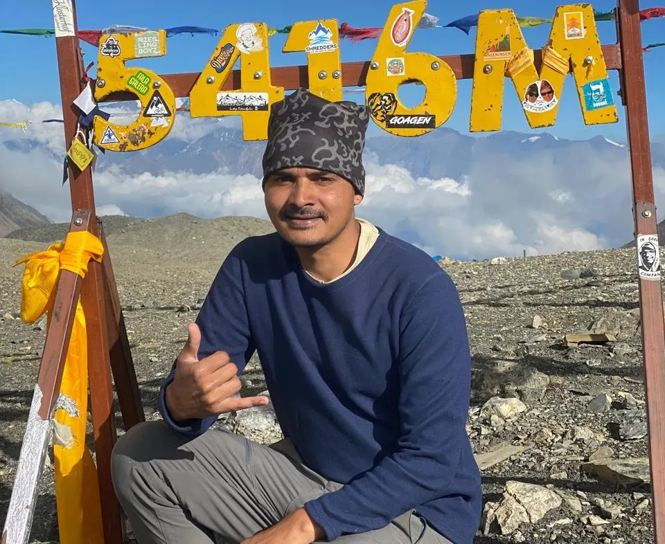
The Manaslu Circuit is, without question, one of the finest trekking routes out there. I first did this trek back around 2012–2013, guiding two older American guests at the time. Now, in 2024, I’m heading back onto this same route — this time with European (Dutch) guests.
The Manaslu Circuit does come with its share of difficulty, but that difficulty is exactly what makes the reward of completing it so special. I work as an IT person for my company, but this time around, I made a decision to go along on the trek myself, guide my guests, and document the entire experience — turning it into a blog or article so others can read about it and take away something useful, whether that’s practical knowledge or just a sense of what the journey is like.
The Manaslu Circuit is typically a 12-day trek. My guests this time were both a few years younger than me and in excellent physical shape — strong, capable trekkers. The three of us — myself and my two guests — set off together on this journey.
Looking back, my first experience crossing Larke Pass in 2012–2013 gave me a joy unlike anything else, and honestly, even now, just remembering that moment brings a smile to my face. One thing that’s changed since then: back in 2012–2013, we had to start the trek all the way from Aarughat on foot. Now, the road has been extended much further — vehicles can drive all the way to Machha Khola. So instead of walking from Aarughat, we start the actual trekking portion from Machha Khola, covering roughly seven to nine days of walking before reaching Dharapani, where we pick up local transport again for the return journey.
That’s the overview — the rest of the story is in the day-by-day itinerary, based on everything I experienced along the way. I hope it’s genuinely helpful to anyone planning to do this trek themselves.
Trek Overview
- Trek Duration: 12 days
- Trek Difficulty: Challenging
- Trek Date: 11th Sep, 2024 (Monsoon Season)
- Transportation Used: Local Bus from Kathmandu to Machha Khola, Shared jeep from Dharapani to Besi Sahar, Public Bus/Van from Besi Sahar to Kathmandu
Outline Itinerary
Day 1: Kathmandu → Machha Khola
Day 2: Machha Khola → Jagat
Day 3: Jagat → Deng
Day 4: Deng → Namrung
Day 5: Namrung → Shyala
Day 6: Syala → Pungyen Gumba (side trip) → Samagaun
Day 7: Samagaun (Acclimatization Day) → Manaslu Base Camp
Day 8: Samagaun → Samdo
Day 9: Samdo → Dharamsala
Day 10: Dharamsala → Larke Pass (5,106m) → Bhimtang
Day 11: Bhimtang → Dharapani (Acclimatization Day Skipped)
Day 12: Bhimtang → Dharapani (Final Trekking Day)
Day 13: Dharapani → Besisahar (by jeep) → Departure
Detailed Itinerary
Day 1: Kathmandu → Machha Khola
- Drive Route: Kathmandu(Thamel) – Nagdhunga – Malekhu – Taribesi – Salyantar – Arughat – Arkhet Bazaar – Soti Khola – Machha Khola
- Lunch:
- Kathmandu to Machha Khola Distance: 162.5km (101 miles)
- Sleeping Altitude: (900m)
- Overnight: Machha Khola
We gathered at the office early in the morning to meet up before setting off. I was there as the guide for this trek, along with my two guests for the trip. We met in front of the office and boarded a local bus by 8 AM, departing Kathmandu right on schedule, heading toward Machha Khola.
Along the way, the driver played local Nepali music, which made the long ride lively. The scenery outside was stunning too — rivers, green hills, and forest views rolled past the window one after another.
We reached Machha Khola at 3 PM. It turned out to be a small bazaar, so I picked up a few things I’d forgotten to pack — socks, gloves, and toilet paper. Afterward, I took a short walk around the village with my guests to give them a feel for the area. We heard from locals that there was a natural hot spring nearby, so we went to check it out and spent some time there enjoying it before heading back.
We ordered food for dinner and sat down to eat around 7 PM, along with some fresh fruits. Over dinner, I talked with my guests about tomorrow’s itinerary, planning out the next leg of the trek. Afterward, we wished each other good night and headed to our rooms to rest up for Day 2.
Day 2: Machha Khola → Jagat
- Trek Route: Machha Khola – Khorlabesi – Tatopani – Dovan – Thul Dhunga – Yaru Khola – Jagat
- Lunch:
- Machha Khola to Jagat Trek Distance: 22 kilometers (13.7 miles)
- Hike Duration: Around 6-8 hrs
- Sleeping Altitude: (1,340 m)
- Overnight: Jagat
Today was our second day on the Manaslu Circuit Trek, and my destination for the day was Jagat. The distance from Machha Khola to Jagat is about 22 kilometers (13.7 miles), which normally takes around six to seven hours of walking to reach.
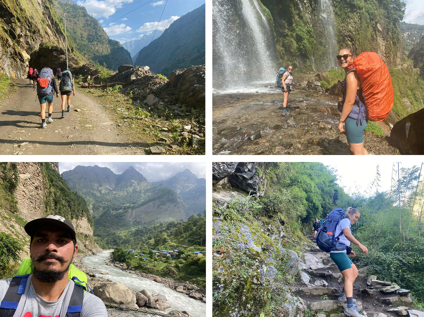
I started the day with a warm breakfast in Machha Khola early in the morning, and by around 7:30 AM, I left Machha Khola with my guests and continued on toward our next destination. Much of the trail followed the main road for almost the entire stretch, which made for a pleasant walking experience. A river ran alongside us for most of the way, and I spotted several waterfalls cascading down the hillsides. The further I walked, the more the mountains kept unfolding in front of me — a view that lifted my spirits.
Partway through the day, I stopped for lunch and took a rest of about an hour to an hour and a half before continuing on toward Jagat. Once I arrived, I checked into my hotel and got my guests settled in for the night. In the evening, I ordered dinner and ate around 7:30 PM, followed by some fresh fruits afterward. I wrapped up the night with the usual goodnight greetings before heading to my room to rest up for Day 3.
Day 3: Jagat → Deng
- Trek Route: Salleri – Sirdibas – Philim – Chisapani – Nyakphedi – Pewa – Deng
- Lunch:
- Jagat to Deng Trek Distance: 19 to 20 kilometers (11.9 to 12.4 miles)
- Hike Duration: 6-7 hrs
- Sleeping Altitude: (1,860 meters / 6,102 feet)
- Overnight: Deng
Today my destination was Deng. I started early in Jagat with a good breakfast, and by around 7:30 AM, I packed up and left. Before heading out, I made sure everyone’s permits were checked and verified in Jagat, since that’s a checkpoint along the route.
As I moved forward, the trail just kept getting more beautiful — waterfalls, hills, and rivers made the whole walk feel magical. At one point, the trail actually passed right beneath a waterfall, so I got a little wet walking through it, which was a fun moment. I stopped to take plenty of photos and videos along the way. The further I walked, the more energy and excitement built up in me and my guests — we were all in great spirits.
I reached Philim village and took a short break there. This gave me and my guests a chance to interact with the local kids and villagers — seeing their day-to-day lifestyle was genuinely heartwarming. After resting a bit, I continued on toward Deng, passing through Chisapani. As I went further, the trail moved off the motor road, and this is where I started noticing mules and donkeys being used by locals to carry loads and transport goods — a common sight in these parts of the trail. I also spent time chatting with local kids and playing with the village dogs along the way.
About an hour and a half past Philim, I reached a diversion point — one path leads to Tsum Valley and continues on the Manaslu Circuit, while I crossed a bridge toward Nyak Phedi, leaving the Tsum Valley route behind. From there, I pushed on a bit further and finally reached Deng, my destination for the day.
Once in Deng, I checked into my hotel and got my guests settled into their rooms. I ordered dinner and stepped out for a short walk around the area before settling down to eat. Dinner was around 7:30 PM, along with some fresh fruits afterward. I wrapped up the evening with the usual goodnight greetings before heading to my room to rest for the next day.
Day 4: Deng → Namrung
- Trek Route: Rana – Bihi Phedi – Bur – Ghap – Jungle Hotel – Suksum – Namrung
- Lunch:
- Deng to Namrung Trek Distance: 18 to 19.5 kilometers (11.2 to 12.1 miles)
- Hike Duration: 6-8 hrs
- Sleeping Altitude: 2,630 meters (8,629 feet)
- Overnight: Namrung
I woke up again around 6:30 AM and got ready for breakfast, which was scheduled for 7 AM. I needed to be ready to start walking by 7:30. I had a delicious breakfast at Hotel in Deng, prepared for me and my guests. After breakfast, I left Deng at 7:30 AM and headed toward today’s destination, Namrung.
The trail leading toward Namrung was noticeably narrower than what I’d walked so far — the higher I climbed, the less it resembled a motor road and the more it became a simple footpath. I crossed several suspension bridges and passed through a few landslide-prone areas along the way. I also spotted waterfalls along the trail, and I stopped for short breaks at small teahouses and shops to rest.
Continuing on, I reached Ghap, where I got a beautiful view of the Himalayas. I took some time to rest there before pushing on, with a river running alongside the trail for much of the stretch. The hike was incredibly pleasant — rivers, waterfalls, greenery, suspension bridges, mani walls, and mules carrying loads all made the day feel truly special.
I stopped for lunch along the way and rested for about an hour to an hour and a half before continuing toward Namrung. As I got closer, I began passing nearby monasteries, walking through chortens and up and down hills, taking in the views. I came across young monks dressed in their red robes, and watching their daily lifestyle left me genuinely amazed and happy. Some of the young monks were carrying food and rations back to their monastery. They were remarkably friendly and innocent, and I walked alongside them until we reached their monastery. I gave them a small amount of money — not because they asked for it, but simply out of my own happiness and goodwill.
After that, I finally reached Namrung. I checked into my hotel and rested for a bit before ordering dinner for the evening, set for 7:30 PM. I had dinner right on time, followed by fresh fruits — my guests were in great spirits too, chatting happily through the meal. Afterward, we sat together in the dining room with a map, discussing the days ahead — how we’d approach the trail, what to expect, and how to make the rest of the trip go smoothly. It was a good chance to interact with other trekkers as well. On that happy note, I wrapped up the day, and after exchanging goodnight greetings, I headed to my room to rest.
Day 5: Namrung → Shyala
- Trek Route: Lhi – Namsang Khola – Shyo – Lho Gaun – Shyala
- Lunch:
- Namrung to Shyala Trek Distance: 10 to 14 kilometers (6 to 9 miles)
- Hike Duration: around 6 hrs
- Sleeping Altitude: (3500 m)
- Overnight: Shyala
Today’s journey took me and my guests from Namrung to Syala, passing through villages like Lhi, Namsang Khola, and Lo Gaun along the way. I started the day early with breakfast in Namrung, and by 8 AM, my guests and I checked out of the hotel and set off on the trail.
Along the way, my guests and I stopped at a scenic viewpoint nearby to take some photos of the beautiful morning scenery before continuing on. As we climbed higher, the air grew noticeably colder due to the increasing altitude, and the trail itself became a bit tougher to navigate. Along the route, we passed several small chortens and monasteries which is decorated with prayer flags. We continued on past all of these landmarks, taking in the sights together.
The stretch from Lo to Syala was especially beautiful, with bridges and greenery surrounding the trail throughout. As we gained altitude, both my guests and I started to feel a bit more fatigue, so we paced ourselves and walked more slowly, taking breaks in between to keep going steadily. Eventually, we reached Syala, which sits at an altitude of about 3,480 meters.
Once we arrived, I let my guests rest for a while to recover from the day’s fatigue, and then placed an order for dinner, set for 7:30 PM. In the meantime, we went together to explore some nearby monasteries. Around 7:30–8 PM, we had dinner, followed by fresh fruits, with my guests enjoying the meal after a long day’s walk. After exchanging our evening greetings, we each headed to our rooms to rest for the night.
Day 6: Syala → Pungyen Gumba (side trip) → Samagaun
- Trek Route: Shyala – Pungyen Monastery – Samagaon
- Lunch: Shyala
- Trek Distance: 13 km
- Hike Duration: 6 hrs
- Sleeping Altitude: (2105m)
- Overnight: Samagaon
Syala is one of those rare places where you feel like the mountains are standing right in front of you — so many peaks visible almost within arm’s reach. After spending the night in Syala, the next day was set aside for a special side trip: a visit to Pungyen Gumba (Pungyen Monastery).
I woke up early, around 4 AM, along with my guests to get ready for the hike. After breakfast, I packed some extra food — rotis and chapatis — since the round trip to Pungyen Gumba and back takes around six to seven hours, and there are no teahouses or food stops along the way. So a packed lunch was essential for all of us.
From Syala, the mountain we could see most clearly was Mount Manaslu, incredibly close and commanding. Sitting there in Pungyen, my guests and I almost felt like we were sitting inside a bowl formed by the Himalayas themselves. Along with Manaslu, we could pick out Manaslu North(6,994m), Himalchuli, Nikey Peak, Naike Col (5,600m), North Col(7,100m), Chamar (7,100 m), Saula Himal, Ngadi Chuli, Ganesh Himal, and several other peaks lining the range.
After soaking in those morning views, my guests and I set off toward Pungyen Gumba with our packed lunches — one of the true highlights of the entire Manaslu trek. We followed a flat trail through yak pastures and forest, and as the path gradually opened up, Manaslu appeared massive right in front of us, along with clear views of Himalchuli and Nagdi Chuli. The total side trip was about 6-7 km and took us around 4 hours to complete. The route to Pungyen Gumba starts with a gentle uphill climb for about 30–45 minutes, after which the trail leveled out again.
From Pungyen Gumba, the view was simply magnificent — paired with a quiet, spiritual atmosphere that made the whole place feel deeply peaceful. Only a few monks live there, which added to the sense of isolation and serenity. We also got to see the Pungyen Glacier from the site. Standing there, both my guests and I felt a real sense of pride and accomplishment. We spent some time taking photos around the monastery and its surrounding scenery before heading back down to Syala, a return journey of about four hours.
Back in Syala, we had lunch and packed our bags for the day’s onward destination: Samagaun. After lunch, we set off from Syala toward Samagaun, walking with our backpacks on, stopping for photos, taking in the stunning views, and enjoying music along the way. We passed through green pasture land and yak pastures, laughing and playing as we went. Along the trail, Manaslu once again appeared massive, alongside Himalchuli and Ngadi Chuli, and we passed several monasteries, mani walls, and green fields. The trail itself was mostly straightforward, and the three of us — myself and my guests — walked it in high spirits, thoroughly enjoying every part of it.
Once we reached Samagaun, we checked into our teahouse and spent the rest of the evening relaxing. Samagaun even has a pool house — if anyone’s interested in pool or snooker, there’s a place right there to play.
Day 7: Samagaun (Acclimatization Day) → Manaslu Base Camp
Today was the seventh day of the trek, and it was set aside as an acclimatization day in Samagaun. Because of that, I let myself and my guests sleep in a little later than usual. Our plan for the day was to hike up to Manaslu Base Camp, so we had breakfast around 8–8:30 AM and got dressed in the basic layers we’d need for the trek up.
My guests and I set off together, along with several other trekkers and guides from other groups who were also headed to Base Camp that day. We left the teahouse at 9 AM and began the climb. Early on, we passed by a large glacial lake called Birendra Lake. From there, we continued climbing for roughly four to five hours before finally reaching Manaslu Base Camp. At Base Camp, we even spotted a small wild creature — something like a wild Himalayan rat.
Reaching Base Camp was a genuinely exciting moment. My guests and I hugged each other and exchanged congratulations for making it. We rested there for a while, had some tea, biscuits, and a light snack, before starting our descent back to Samagaun for the night.
The way down was noticeably easier than the climb up, since it was mostly downhill. Instead of following the same trail back, we took a slightly different route. On the way, we passed by Birendra Lake again and had to cross it — this time, I had to carry my guests across to get them safely to the other side. Once across, we made our way back to Samagaun, our destination for the night.
Back in Samagaun, I let everyone rest before dinner. We had dinner along with fresh fruits, and after exchanging our usual goodnight greetings, we headed to our rooms to prepare for the next day’s shorter journey.
Samagaun is also home to a Buddhist monastery, where visitors can learn about Buddhism and its teachings. My guests and I didn’t get a chance to visit it this time, but it’s definitely worth exploring if you’re interested.
Day 8: Samagaun → Samdo
- Trek Route: Samagaon – Birendra Lake – Samdo
- Lunch: Samdo
- Trek Distance: 8 kilometers (5 miles).
- Hike Duration: 3-4 hrs
- Sleeping Altitude: (3,820 m)
- Overnight: Samdo
Since today was a shorter walking day, I had breakfast with my guests around 7:30 AM in Samagaun and got our backpacks ready for the trek to Samdo. Before setting off, I also checked in with the company to let them know we’d made it this far, and my guests spoke with the company owner as well to share an update.
By around 8 AM, I picked up my backpack and set off with my guests toward Samdo. The walk to Samdo usually takes about two to three hours, so there was no rush — we took it slow and steady along the trail.
Being at such high altitude now, the change in scenery was noticeable. The vegetation, landscape, and greenery all looked different, and even the wildlife had shifted to distinctly high-altitude species. We spotted marmots, chinchillas, and a few other unique animals along the way. On the route to Samdo, we passed a yak pasture, mani walls, and chortens, crossing several such landmarks along the trail. A river ran alongside us in the opposite direction for almost the entire walk.
When we reached Samdo, we really got to soak in the full beauty of the place. Since it was monsoon season, I was pleasantly surprised — the day turned out sunny and clear, and luckily it didn’t rain at all. Thanks to the good weather, we were able to enjoy excellent views throughout.
Once in Samdo, we checked into our teahouse and rested for a bit. After lunch, my guests and I explored some of the nearby spots, took plenty of photos, and made some good memories before settling in for the rest of the day in Samdo.
Day 9: Samdo → Dharamsala
- Trek Route: Larkey Bazaar – Dharamshala
- Lunch: Dharamshala
- Trek Distance: 7 km
- Hike Duration: 3-4 hrs
- Sleeping Altitude: 4,460 meters (14,633 feet)
- Overnight: Dharamshala
Today I trekked from Samdo to Dharamsala — a destination where teahouses are quite limited. Facilities like internet and hot water are hard to come by here; hot water is available, but usually at an extra cost, and electricity and Wi-Fi aren’t available at all.
I had breakfast in Samdo early in the morning with my guests, and we set off for Dharamsala around 7:30 AM. Along the way, the trail passed through yak pastures, where we spotted yaks and Chauris grazing, along with a few Marmots. Combined with the stunning Himalayan views throughout, it made for a memorable walk — one we made sure to capture on our cameras and phones.
After about two and a half to three hours of walking, we reached Dharamsala. Once there, I found a room in one of the few small teahouses, dropped off our backpacks, and headed back out with my guests to take in the surrounding mountain views and snap a few more photos. Dharamsala sits at a high altitude, so the air was noticeably colder — but fortunately, neither I nor my two guests showed any signs of altitude sickness. We were all in good spirits and settled into Dharamsala comfortably.
For dinner, we placed our order early, around 3:30–4 PM, since meals at this altitude are quite limited. Because firewood is scarce here, teahouse owners generally prefer that everyone in a group order the same or similar dish, to make cooking more efficient. Still, we managed to order what we each preferred. We had dinner around 6:30–7 PM, and after our usual evening greetings, we headed to bed for the night.
Day 10: Dharamsala → Larke Pass (5,106m) → Bhimtang
- Trek Route: Dharamshala – Larkey La Pass – Larkey Phedi – Bhimtang
- Lunch: Larkey Phedi
- Trek Distance: 19 km
- Hike Duration: 8-9 hrs
- Sleeping Altitude: 3,720 meters (12,205 feet)
- Overnight: Bhimtang
Today was one of the most challenging and important days of the entire trek. From Dharamsala, I had to cross Larke Pass — the highest point of the Manaslu Circuit — and continue all the way down to Bhimtang, in Mustang district. The route was long, and with the high altitude came thinner oxygen, which made the day physically demanding for all of us.
To make sure the difficulty didn’t get the better of us, I woke up at 4 AM in Dharamsala along with my guests, had a quick breakfast, and set off right away — we knew we needed an early start to cross Larke Pass safely. Besides me and my guests, several other trekkers joined the group heading up as well. We geared up with headlamps, gloves, and sunglasses, packed warm clothing in our backpacks, and began the climb.
I had estimated the climb to the pass would take about four hours, so I kept the pace steady and unhurried for everyone, to avoid any risk of altitude sickness. We moved forward gradually — a bit of climbing, a flatter stretch, then climbing again — steadily working our way up.
Since we’d started in the dark at 4 AM, we couldn’t see much of the mountain scenery at first. But as dawn broke and the sun began to rise, massive peaks and towering rock faces appeared on either side of us, and the whole group — my guests, the other trekkers, and I — felt a surge of joy taking it all in. We captured as much of it as we could on camera.
After about four hours of climbing, we finally reached Larke Pass, at 5,106 meters. Reaching that point was an incredibly emotional moment for me and my guests — we shook hands, hugged, and congratulated each other on successfully making it. We took photos of the mountains and of each other to mark the memory, then began our descent toward Bhimtang, today’s destination.
The path down from Larke Pass was all downhill, but it was a bit risky and tricky in places. I advised my guests to walk carefully and slowly, since the trail could be slippery. Even though it was monsoon season, there wasn’t much snow, so the walking itself wasn’t too difficult — but a few slippery patches caught both me and one of my guests off guard, and we each slipped at one point. Neither of us was hurt, so we got back up, reminded each other to be careful, and continued on.
After about two to three hours of descending, we could see green, grassy hills in the distance — a landscape shift that lifted everyone’s spirits again. The terrain became noticeably easier and more pleasant from there. We reached Bhimtang around 2–3 PM in the afternoon. Bhimtang is a beautiful village with several cottage teahouses, and unlike Dharamsala, it’s well equipped — electricity, water, and Wi-Fi were all available.
We checked into our teahouse around 2–3 PM and spent the rest of the day relaxing. In the evening, we placed our dinner order around 5–6 PM and ate around 7 PM, followed by fresh fruits. Over dinner, my guests and I shared our experiences from crossing Larke Pass and congratulated each other once again on a successful crossing. With that, we wrapped up the day, exchanged our goodnight greetings, and headed to our rooms to rest.
Day 11: Bhimtang → Dharapani (Acclimatization Day Skipped)
My original itinerary had built in an acclimatization day at Bhimtang. However, my guests were feeling a bit fatigued and preferred not to rest for a full day — they wanted to press on rather than pause. Respecting their wishes, I called the company to inform them of the change, and once they gave the go-ahead, we adjusted the itinerary to skip the rest day and head straight toward Dharapani instead.
Had we taken the acclimatization day in Bhimtang as originally planned, we would have gone to visit Ponkar Lake — a truly beautiful spot, scenic and something everyone tends to love. I’d been looking forward to showing my guests that lake, but given their lower physical stamina at that point, we decided it was best to skip that day and continue directly on to Dharapani.
Day 12: Bhimtang → Dharapani (Final Trekking Day)
- Trek Route: Bhimtang – Yak Kharka – Surki Khola- Goa – Tilije – Dharapani
- Lunch:
- Trek Distance: 15 km
- Hike Duration: 6 hrs
- Sleeping Altitude: 1,860 meters (6,102 feet)
- Overnight: Dharapani
As usual, I woke up at 7 AM, had breakfast, and got my backpack ready for what would be the final day of trekking — today’s destination was Dharapani. The entire route down was downhill. After breakfast, my guests and I left Bhimtang around 7:30 AM and began our descent toward Dharapani.
Along the way, we passed through beautiful greenery, dense forest, and several river crossings. As we walked, my guests and I chatted happily, reminiscing about our whole trekking experience so far and enjoying some light-hearted conversation. Partway through, we stopped at a teahouse for a meal and rested for about an hour before continuing on toward Dharapani.
The trail itself was easy in terms of terrain — all downhill — but with my stamina a bit worn down from the trek, my body was aching, so even the downhill stretches felt a bit demanding for me. My guests, on the other hand, held up remarkably well — both of them ladies, a few years younger than me, with impressively strong stamina. They walked the whole way cheerfully, and we kept the mood light with conversation and photos, occasionally turning back for one last look at the mountains — since the lower we descended, the smaller the peaks appeared behind us. We took a moment to look back and say our goodbyes to the mountains before continuing on.
About two to three hours after our meal stop, we finally reached Dharapani. We dropped our backpacks off at a teahouse and settled in to rest. Once we were checked in, we placed our order for dinner and rested a while longer.
My guests were in great spirits and decided to celebrate with a small beer party, marking the successful completion of the Manaslu Circuit and Larke Pass trek. I’m not someone who drinks, so while I joined in the celebration and supported the moment, I didn’t have any beer myself. My guests enjoyed their drinks, congratulating each other on a successful trek. Afterward, we had dinner together, followed by fresh fruits, and after exchanging our goodnight greetings, we settled in for the night at our teahouse in Dharapani.
Day 13: Dharapani → Besisahar (by jeep) → Departure
- Trek Route: Besi Sahar
- Lunch:
- Drive Distance: 35 to 40 kilometers
- Drive Duration: 3-4 hrs.
- Sleeping Altitude: 827 m /1400m
- Overnight: Pokhara / Kathmandu
Today marked the final day of our trekking journey — the actual walking portion of the trek ended in Dharapani. From there, the rest of the way to Besisahar had to be covered by jeep. I asked the hotel owner to help arrange a jeep, and he sorted one out for us. Since the road runs through a somewhat underdeveloped area, the jeep fare was a bit on the higher side — which is fairly normal for that kind of route. Even so, we paid what was asked and boarded a shared jeep, which included other trekkers and groups heading the same way.
After about two to three hours on the road, we reached Besisahar. This is where my guests and I parted ways for our onward journeys — they were headed to Pokhara, while I was returning to Kathmandu. I made sure to arrange a bus for them to Pokhara before we said our final goodbyes. Before they left, we exchanged our last round of greetings, and they were kind enough to thank me for a successful trek and even gave me a tip, which I happily accepted.
After seeing my guests off on their microbus to Pokhara, I bought a ticket for the bus back to Kathmandu and made my way home. And with that, our full 12-day Manaslu Circuit Trek came to a close. I felt genuinely happy with how everything went, and so did my guests — and honestly, that’s what mattered most.
What to Pack for the Manaslu Circuit Trek?
Based on my own experience on this route, here’s what I’d recommend packing:
Clothing
- Warm base layers and a good insulated jacket (down or synthetic) — it gets noticeably colder as you gain altitude, especially around Samdo, Dharamsala, and Larke Pass
- Trekking pants and a few quick-dry t-shirts/long sleeves
- Rain jacket or poncho (especially important if trekking during monsoon season)
- Warm gloves and a hat/beanie — essential for the pre-dawn Larke Pass crossing
- Sunglasses/UV-protection glasses — the glare near the pass and glaciers is intense
- Buff or scarf to cover your face/neck against wind and cold
- Good trekking socks (pack extra pairs — easy to forget, and small shops like the one in Machha Khola may not always have what you need)
- Sturdy, broken-in trekking boots
- A pair of light shoes or sandals for evenings at teahouses
Gear
- Headlamp with extra batteries — non-negotiable for the early morning Larke Pass push
- Trekking poles — genuinely helpful on the steep, sometimes slippery descent from the pass
- A good sleeping bag rated for cold temperatures (teahouses at higher altitude get cold at night)
- A daypack/backpack with a rain cover
- Reusable water bottle and water purification tablets or a filter
Practical Essentials
- Toilet paper and hand sanitizer (limited or unavailable in remote teahouses)
- A basic first-aid kit, plus any personal medication
- Diamox or altitude sickness medication (consult a doctor beforehand)
- Cash in Nepali rupees — no ATMs once you’re past the lower villages, and things get pricier the higher you go
- Power bank — electricity and charging aren’t always available at higher altitudes
- Snacks/energy bars — useful on long stretches like the Pungyen Gumba side trip or the Larke Pass crossing, where teahouses are hours apart
Permits & Documents
- TIMS card, Manaslu Restricted Area Permit (RAP), and Annapurna Conservation Area Permit (ACAP) — checked at checkpoints like Jagat
- Passport-size photos and copies of your passport for permit processing
Optional but Nice to Have
- Camera or phone with extra storage — you’ll want it for the mountain views from Syala, Pungyen, and the pass itself
- A small notebook or journal, if you like documenting the trip like I did
| Manaslu Tsum Valley Trek – 13 Days Trekking in Nepal From To US$ 815 Save US$ 310 |  View Trip |
How Difficult Is the Manaslu Circuit Trek?
Based on my own experience guiding this trek, I’d rate the Manaslu Circuit as moderate to challenging — it’s not a trek for absolute beginners, but with reasonable fitness and the right preparation, most trekkers can complete it successfully.
What makes it demanding:
- High altitude: The trek climbs from around 900m at Machha Khola all the way up to Larke Pass at 5,106m. That’s a significant altitude gain over the course of the trek, and the risk of altitude sickness is real, especially in the final few days approaching the pass.
- Larke Pass itself: This is the toughest single day of the trek. It requires a 4 AM start, roughly 4 hours of climbing in the dark and cold to reach the pass, followed by a long, sometimes risky and slippery descent down to Bhimtang. I’ve seen guests slip on the way down, myself included — it demands care and slow, steady footing rather than speed.
- Long trekking days: Several days involve 6-7 hours of walking, and on the acclimatization/side-trip day to Manaslu Base Camp, you’re looking at closer to 8-9 hours round trip.
- Limited facilities at higher elevations: Once you’re past Samdo and into Dharamsala, teahouses are basic — no electricity, no Wi-Fi, limited food options, and everyone in a group is often asked to order the same meal due to firewood scarcity.
- Remote and rugged terrain: Narrow trails, suspension bridges, landslide-prone sections, and steep motor-road-to-footpath transitions (especially between Deng and Namrung) all add to the physical demand.
What makes it manageable:
- A built-in acclimatization day in Samagaun (Day 7) gives your body time to adjust before pushing higher.
- The trail is well-established with teahouses along nearly the entire route (except at very high points like Dharamsala), so you’re not carrying heavy camping gear.
- Gradual altitude gain for most of the trek, with the real jump happening only in the final approach to the pass.
- Physical fitness matters more than technical climbing skill — there’s no technical mountaineering involved, just sustained walking at altitude.
My honest take: If you have decent hiking fitness, don’t rush, listen to your body regarding altitude symptoms, and go with an experienced guide, the difficulty is very manageable. The hardest single stretch by far is Larke Pass day — everything before that builds up gradually, and everything after is a straightforward, mostly downhill walk out.
I’d put it a notch above the Annapurna Circuit in terms of remoteness and trail difficulty, though comparable in terms of altitude challenge.
How Busy Was the Trekking Route?
From what I experienced, the Manaslu Circuit is far less crowded than more popular routes like the Annapurna Circuit or Everest Base Camp trek — it has a much quieter, more remote feel overall.
That said, it wasn’t completely empty either. A few things stood out from my own trek:
- Larke Pass day was the busiest stretch by far. Since most trekkers time their crossing for early morning (around 4 AM starts), I ran into several other guides and their guests from different trekking companies all making the push at the same time. It felt more like a shared, communal effort on that one critical day.
- The jeep from Dharapani to Besisahar was a shared ride — my guests and I weren’t the only ones in the vehicle; other trekkers and groups leaving the circuit around the same time joined the same jeep.
- Along the main trail on most other days, though, it was fairly quiet — occasional encounters with other trekking groups, but nothing like the crowds you’d see on more mainstream routes. Much of the trail felt personal, with just my guests, the local villagers, kids, and animals like mules, yaks, and dogs for company.
- Restricted area permits (required for Manaslu) naturally keep trekker numbers lower than fully open routes, since it limits how many people take this path compared to unrestricted circuits.
So overall: quiet and remote for most of the journey, with a noticeably busier, more social atmosphere concentrated around the Larke Pass crossing itself, where paths from different groups converge before spreading out again on the descent to Bhimtang.
Best Time / Season to Trek
Most trekkers do the Manaslu Circuit in spring (March–May) or autumn (September–November), when the skies are clearer and mountain views are at their best. My own trek this time actually fell during monsoon season, which isn’t the typical choice — but I was pleasantly surprised. Aside from one or two overcast stretches, my guests and I got lucky with mostly sunny, clear days, including good visibility at Samdo and along the ridge toward Larke Pass.
Monsoon does mean a higher chance of rain, leeches at lower elevations, and occasional trail muddiness, so I made sure to carry proper rain gear for myself and reminded my guests to do the same. If you’re flexible, autumn remains my personal recommendation for the most reliable weather — but if monsoon is your only window, it’s still very doable with the right preparation.
Permits & Rough Cost Breakdown
Before starting the trek, I made sure all my paperwork — and my guests’ — was in order. For the Manaslu Circuit, you need three permits: the Manaslu Restricted Area Permit (RAP), the Annapurna Conservation Area Permit (ACAP), and the Manaslu Conservation Area Permit (MCAP), since the route passes through restricted terrain. I had these checked and verified with my guests at the Jagat checkpoint, as I mentioned earlier.
Costs vary by season (restricted area permits are pricier in peak season), and on top of permits, the overall budget for my guests included guide fees, lodging, meals, and the jeep transfer from Dharapani to Besisahar. It’s not the cheapest trek in Nepal given the restricted-area fees, but I always tell my guests it’s worth it for how untouched the route feels.
Guide Arrangement — Wearing Two Hats
This trip was a little different for me personally. I normally work as an IT person for my trekking company, but this time, I decided to step out from behind the desk and guide the trek myself, walking every step alongside my guests rather than just coordinating logistics remotely.
It gave me a much closer, hands-on relationship with my guests than I’m used to — I got to personally check their permits, manage our pace day to day, adjust the itinerary when needed (like skipping the Bhimtang acclimatization day at their request), arrange jeeps, and even carry one of my guests across Birendra Lake. Being both the planner and the one physically leading the group made the whole trek feel more personal, and I think my guests appreciated having that continuity throughout.
Altitude Sickness — What I Watched For
As the guide, keeping an eye on my guests’ health was always on my mind, especially past Samagaun. I made sure we followed a steady, unhurried pace on the way up to Manaslu Base Camp and during the Larke Pass climb, watched for common warning signs like headaches, dizziness, nausea, or unusual fatigue, and kept the group hydrated throughout. Thankfully, neither I nor my two guests showed any real symptoms of altitude sickness at any point — something I was genuinely relieved about, especially given how high and remote sections like Dharamsala and the pass itself are. My general approach with guests is: walk slow, rest when needed, and never push through symptoms just to stay on schedule.
Food & Accommodation Along the Route
The teahouses along the route changed quite a bit depending on altitude. Lower down — around Machha Khola, Jagat, and Deng — there was a decent variety of food, and my guests and I could usually order whatever we liked. Higher up, especially from Samdo through Dharamsala, options became far more limited. In Dharamsala specifically, I had to order dinner early (around 3:30–4 PM) since teahouse owners there prefer the whole group to order similar dishes, given how scarce firewood is at that altitude.
Accommodation followed a similar pattern — comfortable teahouses lower down, and much more basic setups (no electricity, no Wi-Fi) once we got higher. Bhimtang, on the other side of the pass, was a pleasant surprise with proper facilities again, including a pool table for guests who wanted to unwind.
Connectivity & Communication
Staying in touch got progressively harder as my guests and I climbed higher. Lower villages generally had some Wi-Fi or mobile signal, but by the time we reached Dharamsala, there was no electricity or Wi-Fi at all — a detail I made sure to prepare my guests for in advance so there were no surprises. I also made a point of contacting my company directly whenever we reached key checkpoints, like Samdo, just to update them on our progress and confirm everything was on track.
Why Manaslu Circuit Over Annapurna or EBC
Having guided treks in this region for years, I always tell prospective guests that Manaslu offers something the more popular routes can’t: a genuine sense of remoteness. Unlike Annapurna Circuit or Everest Base Camp, which can feel busy with trekkers at times, Manaslu felt quiet and personal for nearly the entire route, aside from the shared energy around Larke Pass itself. The restricted area permit requirement naturally limits numbers, so my guests and I often had long stretches of trail to ourselves, alongside villagers, kids, and grazing yaks rather than other trekking groups. For guests looking for authenticity over crowds, I always recommend Manaslu first.
Final Reflections
| Manaslu Circuit Trek – 12 Days Trekking in Nepal From To US$ 675 Save US$ 290 |  View Trip |
Looking back, this trek meant something a little different to me this time. I first crossed Larke Pass back in 2012–2013, guiding two older American guests, and that memory has stayed with me ever since — even now, just thinking about that first crossing brings a smile to my face. Coming back in 2024 with new guests, watching the route itself evolve — with roads now reaching all the way to Machha Khola, cutting out days of walking that used to start from Besisahar — felt like witnessing the trek change alongside my own journey as a guide.
This time, I made a deliberate choice to walk the trail myself, guide my guests personally, and turn the whole experience into a written account — partly for my own memory, and partly so others considering this trek could learn something useful from it. By the end, standing in Besisahar and saying goodbye to my guests as they headed to Pokhara and I returned to Kathmandu, I felt a quiet sense of pride — not just in completing the trek again, but in having guided two guests through it safely, happily, and successfully. That, more than anything, is what stayed with me.
20 Frequently Asked Questions — Manaslu Circuit Trek
1. How many days does the Manaslu Circuit Trek take?
Based on my own experience guiding this route, the trek typically takes 12 days of actual trekking, from Machha Khola to Dharapani, plus travel days to and from Kathmandu.
2. What is the highest point of the trek?
The highest point is Larke Pass, at 5,106 meters. I guided my guests across it on Day 10, and it remains the most physically demanding part of the entire journey.
3. Do I need a guide to trek the Manaslu Circuit?
Yes. Since Manaslu is a restricted area, a licensed guide is mandatory, and permits are issued only through registered trekking agencies. I personally checked and managed my guests’ permits at checkpoints like Jagat.
4. What permits are required for this trek?
You’ll need the Manaslu Restricted Area Permit (RAP), Manaslu Conservation Area Permit (MCAP), and Annapurna Conservation Area Permit (ACAP), since the route crosses into Annapurna Conservation Area territory near the pass.
5. Is the Manaslu Circuit Trek difficult?
I’d rate it moderate to challenging. The toughest single day by far is the Larke Pass crossing, but the rest of the trek builds gradually, and with steady pacing, most reasonably fit trekkers — like my guests — can complete it comfortably.
6. What’s the best season to do this trek?
Spring (March–May) and autumn (September–November) are generally recommended for the clearest views. I actually guided this trek during monsoon season and still got mostly good weather, though I’d recommend autumn for more reliable conditions.
7. Is altitude sickness a concern on this trek?
Yes, especially from Samdo onward. I kept a close eye on my guests throughout, made sure we paced ourselves and stayed hydrated, and thankfully neither I nor my guests experienced any real symptoms.
8. What kind of accommodation is available along the route?
Teahouses are available almost the entire way. Lower down, they’re fairly comfortable with more food options; higher up — especially in Dharamsala — facilities become very basic, with no electricity or Wi-Fi.
9. Is Wi-Fi or electricity available throughout the trek?
Not consistently. I made sure to prepare my guests for the fact that places like Dharamsala have no electricity or Wi-Fi at all, while lower villages generally have some access.
10. How much does the Manaslu Circuit Trek cost?
Costs vary depending on season, permit fees, guide charges, lodging, meals, and transport (like the jeep from Dharapani to Besisahar). Restricted-area permits do add to the overall cost compared to more open routes like Annapurna.
11. What is the trekking route itinerary?
My itinerary ran: Kathmandu → Machha Khola → Jagat → Deng → Namrung → Syala → Pungyen Gumba (side trip) → Samagaun → Manaslu Base Camp (acclimatization day) → Samdo → Dharamsala → Larke Pass → Bhimtang → Dharapani → Besisahar → Kathmandu/Pokhara.
12. Did you have an acclimatization day?
Yes, in Samagaun, where I took my guests on a side trip to Manaslu Base Camp. I had originally planned another acclimatization day in Bhimtang, but my guests preferred to skip it, so I adjusted the itinerary accordingly.
13. What wildlife might you see on the trek?
Along the way, my guests and I spotted mules, donkeys, yaks, chauris, marmots, and even a Himalayan rat near Manaslu Base Camp — the wildlife noticeably changes as you gain altitude.
14. Are there any monasteries along the route?
Yes, several. I took my guests to Pungyen Gumba, one of the true highlights of the trek, and we also passed smaller monasteries and interacted with young monks along the way near Namrung.
15. How busy or crowded is the trekking route?
Much quieter than routes like Annapurna Circuit or Everest Base Camp. My guests and I had long, peaceful stretches to ourselves, with the trail feeling most social around the Larke Pass crossing, where other groups converge.
16. What should I pack for this trek?
I always tell my guests to bring warm layers, a headlamp, trekking poles, sunglasses, a good sleeping bag, rain gear, and cash — since ATMs disappear quickly once you’re past the lower villages.
17. How do you get to and from the trailhead?
I arranged a local bus from Kathmandu to Machha Khola to start the trek, and at the end, a shared jeep from Dharapani to Besisahar, where my guests continued on to Pokhara and I returned to Kathmandu.
18. Is the trail safe for solo trekkers?
Since it’s a restricted area, solo trekking isn’t permitted — a licensed guide like myself is required at all times, partly for permit compliance and partly for safety on remote, sometimes tricky terrain like the Larke Pass descent.
19. What was the most memorable part of the trek for you personally?
Without question, reaching Larke Pass with my guests. I first experienced that feeling back in 2012–2013, and revisiting it with new guests in 2024 brought back that same overwhelming joy and sense of achievement.
20. Would you recommend this trek to others?
Absolutely. I always tell prospective guests that Manaslu Circuit offers a level of remoteness and authenticity that’s harder to find on more popular routes — and having guided it myself twice now, it remains one of my favorite treks in Nepal.
Need Help? / Call Us
+977-9845548583 or Chat with us on WhatsApp
Ask a Question?